
Extreme cold warning: Frostbite is a concern
The Northeast will be blasted by another Arctic cold front that will produce below zero wind chills, snow and high winds that could cause power outages this weekend as a persistent cold pattern continues across the East Coast.
This fresh cold front will move eastward by Saturday. Here’s what you need to know.
high wind threat
Strong northwesterly winds will develop behind a cold front in the east on Saturday and will last through at least Saturday night, if not Sunday morning, as the low pressure strengthens just off the coast.
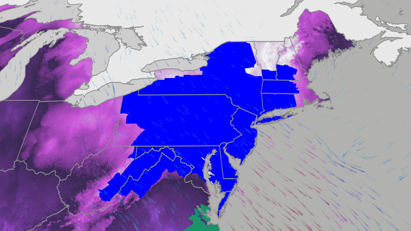
The National Weather Service has issued high wind warnings in the Mid-Atlantic and Appalachians, the darkest purple areas in the map below. This includes Baltimore, Washington, DC, Roanoke, Virginia, and Asheville, North Carolina.
In these areas, winds up to 60 mph can occur, causing power outages and some tree damage.


how cold?
alert
The NWS has also issued an extreme cold warning for parts of the East from New England to eastern North Carolina.
Areas under extreme cold warnings, shown by the darkest blue contour in the map below, include the New York City tri-state, Philadelphia, and Hartford. This means that if you are outside long enough it can get so cold that frostbite or hypothermia can occur.

temperature
Dozens of daily record colds will be in danger Saturday and Sunday, typically ranging from single digits in the coldest spots to the teens in the Northeast and 20s elsewhere and 30s in North Carolina.
By Sunday and Monday morning, lows are expected to be above or below zero across much of the Northeast from Pennsylvania and New Jersey northward, in the teens in Delaware, Maryland and Virginia, and in the single digits in the 20s in North Carolina.
From the New York City tri-state to New England, including Boston, Sunday and Monday could be the coldest mornings of winter so far.


cool breeze
The winds we mentioned earlier, combined with this cold, will bring cold temperatures below zero across much of the Northeast this weekend.
In parts of New York State, New England and the Appalachians, wind chills in the minus teens or even minus 20 are possible.


snow too
Luckily, we’re not expecting another blizzard like the recent Winter Storm Fern, nor Gianna. However, the cold will continue with snowfall in the east till Saturday.
Snowfall totals should be less than 6 inches across most areas, except for the Appalachians, Adirondacks and parts of New England, where slightly heavier snowfall is possible.
The combination of snowfall, possibly known as a blizzard, with high winds could result in significantly reduced visibility and travel in some areas challenging.
(More: What is snow?)


Is any relief coming?
The short answer is, “Yes, to some extent.” We expect temperatures to reach above zero across much of the Interstate 95 corridor by Tuesday.
But, in general, the heat will remain relatively mild in the Northeast during the week compared to the rest of Central America.
(Map: 10-day US forecast high/low)


cold stretch
It has been extremely cold in the east since mid-January.
Dozens of locations in the East were in the top 10 coldest from January 15 through February 15, according to the Southeast Regional Climate Center. 4 three-week periods on record. This was the third coldest period each in Detroit and Pittsburgh, and the coldest since 1963 and 1977, respectively.
It was also Pittsburgh’s coldest January in 12 years.
On Groundhog Day, New York City finally broke a nine-day streak of temperatures at or below zero, its longest streak in eight years.
The nine-day streak at or below freezing was the sixth-longest in Washington and the longest since 1989.
Persistent cold and multiple winter storms have left Philadelphia with at least 5 inches of snow for more than a week in a row, the longest such period since February 2010’s epic Snowmageddon storm.
Jonathan Erdman is Weather.com’s senior meteorologist and has been covering national and international weather since 1996. Extremes and strange weather are his favorite subjects. reach it blue sky, X (formerly Twitter) And Facebook.
<a href=
