Meteorological winter begins on Monday, and what better time to start the season than with a looming winter storm with a nor’easter and the possibility of snow days?
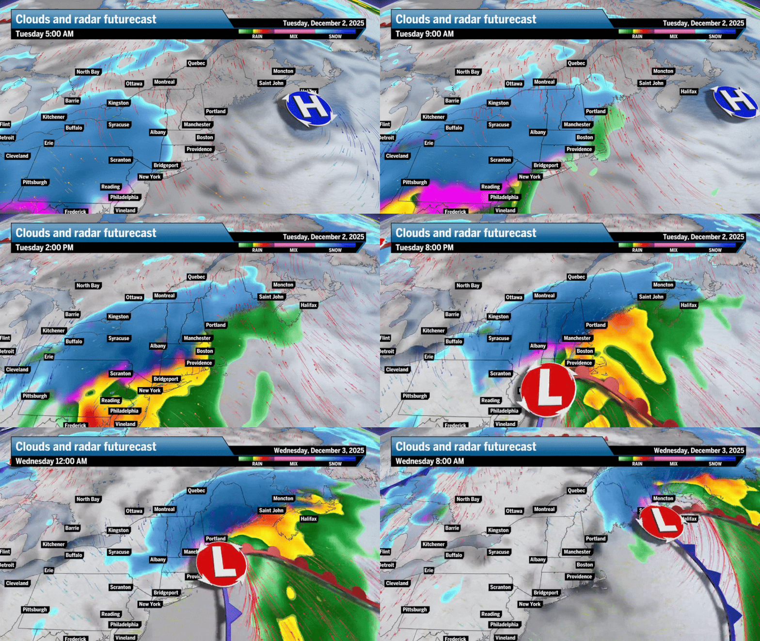
All signs point to an emerging storm starting in the far southeast of the country and moving along the jet stream up the East Coast toward New England between mid-morning and late Tuesday. The fierce storm is expected to end soon, with much of New England cleared by Wednesday morning.
This storm has the potential to develop into a true Nor’easter, but we don’t know yet. The atmosphere is very turbulent, especially with the recent weakening of the polar vortex increasing the likelihood of winter storms. But if the storm moves over coastal waters, northeasterly winds from the ocean will support heavy rainfall across the region.
Where will the rain-snow line fall?
A lot can change, and it will. But so far, it looks like interior parts of New England may still get plowable snowfall on Tuesday. Right now, Boston and east of I-95 may see more rain than snow. I think there will be some snow mixed in between the rain with this system over Greater Boston, perhaps coating up to an inch or two, if I had to commit to total snow now. Areas like Framingham, Worcester and West could see anywhere between 2 to 6 inches, with the Berkshires and parts of Vermont and New Hampshire getting closer to 4 to 10 inches.
I think by mid-morning Monday, we’ll have a reliable snow map for you, but here’s an early look:

Several scenarios could play out in terms of storm track and subsequent snowfall totals, leaving a question mark in the Greater Boston area and coastal New England as to whether we will see rain, a wintry mix, snow, or “D”, all of the above.
I’ll provide some possible snowfall totals with the scenarios below, but these will be subject to change over the next 24 hours as the storm takes shape. The key role here will be how much the pressure on Monday will affect the speed and direction of the incoming storm. So far, it looks like trends show the storm is winning the positional battle, allowing the storm track closer to the coast and allowing some snow to fall in Boston before rain enters the picture. In this situation, there will be more snowfall in western and northern New England.
Boston hasn’t seen above average snowfall in December since 2020, when 13 inches of snow fell in the month, 6 inches more than normal.

Here are three possible scenarios that will become clear by Monday morning. Again, I’m leaning toward the Euro and NAM forecast models meaning there will be some snowfall in Boston before being washed out by rain, with a good amount of snowfall across western and northern New England – not as much as the NAM model suggests, but with widespread totals of 2 to 8 inches.
Scenario No. 1 – Euro shows a deep southern track, with southern New England covered in snow, with low snowfall


Scenario No. 2 – NAM shows an inside track, rain for Boston, snow in the north and west


Scenario No. 3 – The GFS shows a southern track, but closer to the coast. Boston and areas to the north and west received good snowfall.


Forecast rain-snow line: Tuesday 9am, 5pm and 9pm


Total possible precipitation across southern New England on Tuesday:

Strong winds Tuesday and Wednesday morning, regardless of storm direction:


These forecast maps will be updated, so please check back. Sign up here for us daily globe weather forecast Which will be delivered straight to your inbox early every weekday morning.
Ken Mahan can be reached at ken.mahan@globe.com. Follow him on Instagram @kenmahantheweatherman.
<a href=
